


Tallahassee Headquarters located at:
117 South Gadsden Street,
Tallahassee, Florida 32301
(850) 681-3200
Copyright © SalterMitchell PR 2021. All rights reserved.

Behind every hurricane forecast is a team making decisions that can impact millions of lives.
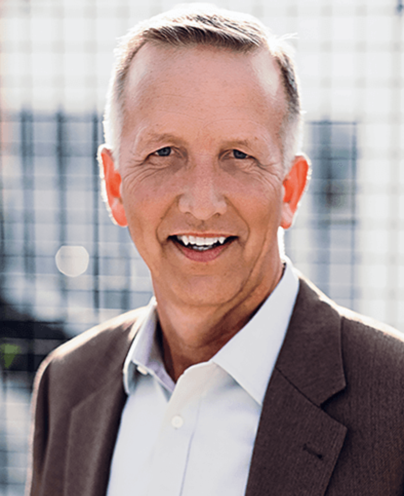
As director of NOAA’s National Hurricane Center, Michael Brennan’s career has been defined by one mission: helping people make better decisions before, during and after a hurricane. From forecasting major storms such as Irma, Michael and Matthew to directly influencing emergency planning and public safety across Florida.
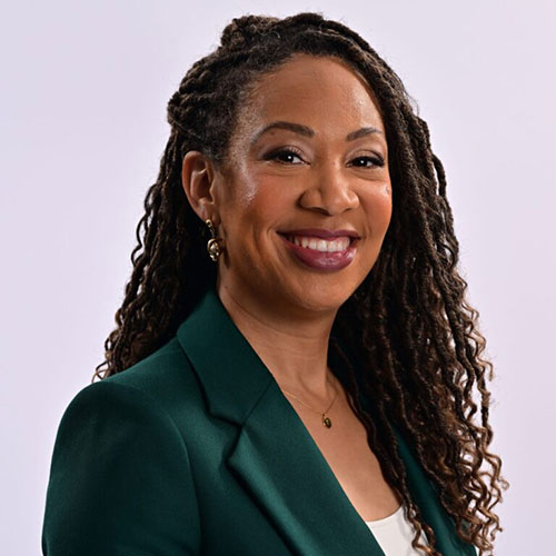
In this episode, SMPR President Heidi Otway sits down with Michael to discuss the human expertise behind every forecast and the responsibility that comes with protecting one of the nation’s most hurricane-prone states.
Heidi Otway: Dr. Brennan, I'm so excited to be talking to you on this Fluent in Floridian podcast. Thank you for joining us from South Florida.
Michael Brennan: Yeah, great to be with you. Thanks.
Heidi Otway: So, tell us a little bit about your Florida story and your upbringing. And of course, we're going to weave that into what inspired you to pursue a career in weather and hurricanes.
Michael Brennan: Yeah, I think like most meteorologists, I had an interest in weather from a pretty early age. I grew up in western Virginia in the Roanoke area along the Blue Ridge Mountains—not exactly a hotbed of hurricane activity, but a pretty interesting place for weather: winter storms, thunderstorms, flooding. So I had an early interest in the weather there, and I ended up going to school at NC State University in Raleigh and did my undergraduate and graduate work there. I finished grad school in 2005 and moved to Florida to start a postdoc position down here in Miami at the Hurricane Center in 2005. Then I got a federal job working for the National Weather Service up in the DC area in 2007 and then came back here in 2008 and I've been back here in South Florida ever since.
Heidi Otway: Yeah. So, you spent a portion of your career, the majority of it, in South Florida with the National Hurricane Center, which is based in my hometown of Miami. So, how is working in Florida, one of the most hurricane-prone states? I mean, literally, it's like destination one for hurricanes in the US. How has that shaped your approach to forecasting and communicating risk?
Michael Brennan: Well, I think when you live in a community where you are at risk of that hazard, you feel that. It's not just a profession, which we're all very dedicated to, but it is part of our personal lives, the lives of our families, our friends, and our communities—it's something we have to prepare for. At the end of May, we're doing a hurricane preparedness seminar day for our own staff here at the Hurricane Center because we have a lot of new people who haven't necessarily gone through a big storm. You talked about Hurricane Andrew and the history of that here, but that's been more than 30 years ago since there's been a storm of that magnitude here in the Southeast Florida metro area. So, it's just a reminder that it's not just your job, it's a calling for most of us. We feel very dedicated to what we do to try to keep people safe, but we're in the process of keeping our own families safe. I have families and friends all throughout the state of Florida and elsewhere in the country. We're located here in South Florida, but our staff is really from across the United States, and we have connections to all different parts of hurricane-prone areas within the country.
Heidi Otway: Yeah. So, I'm a native Floridian, so I've lived through so many hurricanes that when a hurricane comes, I'm like, "Okay, let's get ready." But then we have a lot of new people who've moved into the state over the last few years. I remember reading news reports of them saying, "This is what you all deal with in Florida? I'm not used to this. I don't know what to do." So, how do you and your organization help communicate how to prepare and what to know? Not only for us Floridians who've lived through many hurricanes—and I mentioned to you earlier, I gave birth during Hurricane Andrew down in Miami with my first child—so, how do you communicate to all of us so that we are truly prepared and understand what to expect?
Michael Brennan: Yeah, it's really the main focus of our efforts here in the three or four months that run up to the start of the Atlantic hurricane season in June. We're in the midst of it right now. We're about to undertake a hurricane awareness tour that we do every year along the US coastline. We're doing the Gulf Coast. We're actually going to be in Sarasota on Monday, and we're going to have the hurricane hunter aircraft from NOAA and the Air Force. We'll have staff from the Hurricane Center and the Tampa National Weather Service office. It's basically a day for people to come out and engage with the people who fly into storms and forecast storms, learn more about the threat of storms, and basically remind people that hurricane season's coming. We're going to other stops along the Gulf Coast later in the week. But it's a continual re-education effort every year, not just for new people that are moving to Florida and other hurricane-prone states, but for people who've lived here a long time. We just talked about how here in the Southeast Florida metro areas, we haven't had a major hurricane impact since Wilma in 2005. So, it's a whole generation of people that have lived here, been born here, grown up here without seeing that level of impact in one of the more hurricane-prone communities in the United States. We certainly had a lot of other major hurricane impacts elsewhere in the state in the last few years. We've had 25 hurricane landfalls in the United States since 2017. Numerous ones were here in Florida, particularly along the Gulf Coast itself. So that threat is there every year, and it's a constant re-education effort to remind people of what those threats are. We always start off by making sure people know whether they live in a storm surge evacuation zone. That's really the basis for your entire hurricane plan because if you live in an area where you could be asked to leave, you have to know where you're going to go, how you're going to get there, and what you're going to take with you. You need to have that plan in place before you have a storm.
Heidi Otway: So, Dr. Brennan, how would someone find that out?
Michael Brennan: You can search your local county. Say you live in Broward County like I do; you can search for "Broward County Storm Surge Evacuation Zones" and find the county emergency management web page. They'll have a map. Some counties have a place where you can type in your address and it'll tell you what zone you're in or if you're in a zone at all. The storm surge evacuation zones are pretty big on the Gulf Coast because that surge can penetrate tens of miles inland. In most places along the east coast of Florida, the surge zones tend to be a little smaller, especially in Broward and Palm Beach County—they're generally east of I-95. In Miami-Dade County, they go in a lot farther inland. You get up into Northeast Florida like St. Johns County and up into the St. Johns River. So the surge risk can vary pretty dramatically. But you can look that up by going to your county emergency management office and looking at those maps.
Heidi Otway: Yeah. I have to share an experience. I was doing a live shot on the coast here in North Florida and we were at the beach. I remember I kept looking back because the beach was right behind us and I kept telling the crew, "The water's getting closer. The water's getting closer." And at some point, we had to stop doing the live shots and move further away from the beach because the storm surge was just coming in and coming in and coming in. I was getting nervous about it because the waves were just getting bigger and bigger the longer we were doing the live shots in the hurricane.
Michael Brennan: Yeah, and that's the risk with storm surge. It's not just like water filling up a bathtub gradually. When you have a major hurricane landfall—if you've seen the videos from Fort Myers Beach from Ian or Michael in Mexico Beach—it's a violent push of ocean water inland very quickly with catastrophic wave damage on top. And that's why storm surge still has the potential to kill the most people in any single day of any tropical cyclone hazard. That's why we typically ask people to leave those areas in advance of a dangerous storm to get them out of harm's way. The good news is that elsewhere in Florida, building codes are quite strong. In most modern construction, if you're outside of a storm surge evacuation zone in a well-built home, your home can be your hurricane shelter if you have shutters or impact windows and it's properly built—especially with the post-Andrew building codes that were implemented in places here in South Florida. So, a lot of times you have to make the evacuation achievable for people. You don't have to get in your car and drive to Georgia or North Carolina to get away from a hurricane. You only have to drive tens of miles to get out of that storm surge evacuation zone. As Kevin Guthrie, who's the director of the Florida Division of Emergency Management, says, generally along the east coast, if you can get west of I-95, and along the west coast, if you can get east of I-75, you're generally going to be out of those storm surge zones. You just need to find a shelter—the home of a friend or a relative—to stay at. You can be safe and shelter from the wind hazards, and that'll get you away from that storm surge hazard.
Heidi Otway: Yeah. Thank you. That's such good advice for us Floridians and those who moved into the state. So we're seeing a lot of conversations around the use of artificial intelligence. I'm curious to know if the National Hurricane Center is starting to use this technology to help better determine where storms are going to go and forecasting and such.
Michael Brennan: Yeah, we've been using more crude forms of artificial intelligence in terms of statistical modeling for drought, especially for hurricane intensity going back 30 or 40 years. But we are using some of the more modern machine learning models that we've incorporated into our forecast process. But they're not necessarily the end-all-be-all, the perfect answer for forecasting a hurricane's track or how strong the storm's going to be; they can be very important new tools within our toolbox. We still generally find that instead of focusing on one particular forecast model for track or intensity, a combination of the best models together tends to produce the best and most consistent forecast. I think it's really important for those watching to know that the forecast doesn't just pop out of a computer. There's a forecaster here at the Hurricane Center who's looking at all that data and what the storm's doing now, using their expertise and their knowledge to make that forecast using the best available guidance. There's a real strong human component to that. Especially for intensity forecasting, the human forecast last year really outperformed all the model guidance. So we're adding a lot of value there in the skill and consistency of the forecast, but then also taking what a forecast track and intensity looks like and converting that into how much wind could you expect, what is the storm surge going to look like, and where's the rainfall going to occur—translating that into those individual hazards.
Heidi Otway: Yeah, I'm so glad you said that because you still need the critical thinking of human beings to inform us during these situations. So, you talked a lot about doing forecasting to help us. I mean, all of us are glued to our phones and televisions and radios just to figure out if we are going to be impacted and what does it look like. So, can you share with us where you've done some forecasting that helped save lives or prevented some serious impacts?
Michael Brennan: Yeah. In terms of my own personal forecasting experience, I started here in 2008 as one of the hurricane specialists and was really involved either directly in forecasting or directly supervising the group of hurricane forecasters all the way up until 2023. I think back to storms like Hurricane Irma, Hurricane Michael, and Hurricane Matthew—all storms that were very impactful to Florida—and really being able to get the message out. It's not just the forecast, it's being able to communicate the message, the risk, and the hazards to people. It is really fulfilling knowing that our forecasts are so important. They drive so much decision-making to protect life and property at the individual level, the community level, the state level, and the federal level. You can really see the entire picture come together here. But it's not just during the storm. There's a lot of efforts that go in before we ever have a storm to map out those areas where there is storm surge risk so that counties know where to make those evacuation zones, where to put shelters, and how to develop hurricane evacuation plans. It's the whole picture from preparedness all the way through the event. I think one thing we focused on a lot more in recent years—and I think back to storms like Irma and Michael—is post-storm safety. How do you keep yourself safe after a hurricane, right? Florida has more post-storm hurricane fatalities than any other state in the United States by about a factor of 10. And it's because we have a big population, we are prone to major hurricanes, and some of the demographics are quite vulnerable to post-storm hazards like heat. We have a lot of people that are dependent on medical care or medical devices that may or may not work after a storm in the face of widespread power outages. There's carbon monoxide poisoning from improper generator use and just general post-storm accidents related to recovery or traffic accidents. So we've really started to message post-storm safety. You want people to survive the storm and get out of harm's way, but then stay safe after the event.
Heidi Otway: You know, as you were speaking, it made me think about an experience I had. It was a big storm that hit South Florida and I was very, very young. I drove my car through a puddle of water, and the further I drove, the deeper the water got. I said, "Okay, I need to back up. This is not a good scenario." That's an example of how you just don't know what you're getting into, so you have to be a lot more cautious and aware after the storm.
Michael Brennan: Absolutely. We lose a lot of people to driving their cars into flooded roadways. Freshwater flooding from heavy rainfall has been the biggest killer in tropical storms and hurricanes in the United States over the last 10 years. That's really important because it has almost nothing to do with how strong a storm is, what category the hurricane is, or if it's even a hurricane at all. It just matters how hard it rains and how fast that rain accumulates in a given location. It's really an equal-opportunity hazard that can happen anywhere. Again, a lot of those accidents and fatalities in freshwater flooding are preventable. A lot are related to automobiles and people driving around barricades or into flooded areas, especially at night, because as you experienced, you don't know how deep that water is. The road could be washed out under the water and you could go right off into a creek or river. One of the things in Florida is that it's a relatively flat state and water does not drain quickly. So you can have really prolonged river flooding in the aftermath of a hurricane with heavy rainfall—it can last weeks after the event is over. So, that hazard can linger for a very, very long period of time.
Heidi Otway: Wow. Such impactful information. I hope everyone's taking notes while they're listening to this podcast. I hope you all are enjoying this conversation with Dr. Michael Brennan. We're going to take a quick break for a short message.
Heidi Otway: Okay. So, Dr. Brennan, you've spent years analyzing storms in real time. Are there any "aha" moments in your career when a forecast or prediction worked in surprising or memorable ways?
Michael Brennan: Well, yeah. I think we can go back to Hurricane Melissa, which just happened last year and was one of the most powerful hurricanes we've ever seen in the Atlantic Basin. It made a catastrophic landfall on the island of Jamaica last October as a Category 5 hurricane. But we were really able to anticipate the rapid intensification of Melissa to a degree we've never been able to before. We were able to provide multiple days of lead time—a four-day forecast showing a Category 4 hurricane near the southwestern coast of Jamaica and a three-day lead time for forecasting Category 5 intensity. Those are really new capabilities that we did not have even five or 10 years ago. We would never have had the confidence or the ability to make intensity forecasts that were that aggressive. That's so important to setting the right level of expectation for a storm so that people know what level of storm surge or wind threat they may be dealing with from the very early days. That's one of the challenges we have in Florida—we are very close to where storms can form in the Gulf, the Caribbean, the Bahamas, or the Western Atlantic. So we don't always have 10 days to watch a storm come all the way across the Atlantic. We can have storms like Helen and Michael that form nearby and can make landfall within just three or four days. So, getting those early forecasts right and being able to make forecasts for systems before they even become a tropical depression or tropical storm is vitally important. That's really new ground we've been able to break here at the Hurricane Center in the last 5 to 10 years.
Heidi Otway: Yeah. Well, I'm going to go a little bit off-script here because we have all these different streaming television shows and movies. You have *Twister* and then you have *Sharknado* and all these stories that talk about these weather events almost to the extreme. So, how accurate are these kinds of portrayals from your perspective as a meteorologist? Do you find these fascinating and entertaining, or do you see some real-life storylines in there that folks can learn from at the same time?
Michael Brennan: I think you get the whole gamut depending on what it is. Certainly, there's probably some artistic license taken with the scientific rigor or correctness of it. But I think a lot of the stories can still make a connection because you see the impacts of a particular event on people and the importance of preparedness and knowing what to do when something threatens. A lot of content you see dramatizes people being taken by surprise or having no idea this could happen, and that's really not the case. Here in Florida, we know what those risks are from hurricanes in particular. So it can almost serve as a negative example: you don't want to be caught in a situation where you're not prepared. But it's also a reminder that every storm doesn't just affect a state or a county—it affects people, individuals, families, and communities. That's a really important lesson to learn: that we go through events with the people we love and the people in our community. That's how we survive the aftermath and rebuild—within that community that we live and work in.
Heidi Otway: Yeah. So, we have this thing in Florida that's a meme and it says, "If Jim Cantore comes to your city during hurricane season, you know you gotta batten down the hatches." What is your perspective on that?
Michael Brennan: Well, hurricanes make for great television. Hurricanes have been on TV almost as long as TV has existed, going all the way back to the 1950s and '60s. They're very visual events. There's a lot of potential buildup and drama because it's something that plays out over several days and it's very visual—people see the wind, the ocean, and the heavy rainfall. It is helpful to be able to show people what an event looks like. I think it was probably even more important 30 or 40 years ago when you didn't have video clips that were easily accessible to people and people really couldn't see and hear what a storm actually looked like. Now there's a lot of video online; you can see storm surge and winds and really see the power of what a storm will do. We've even been able to create visuals of what a certain level of storm surge flooding theoretically would look like within a community. You can show a landmark being inundated and make that direct connection for what six feet of flooding looks like in the town where I live. That's a lot more meaningful and easier for people to visualize and understand what the impacts can be.
Heidi Otway: Yeah. One of my favorite videos to watch are the planes that go inside the hurricanes to determine how strong they are. I am just so fascinated by that because they're flying into a hurricane and then they hit the eyewall and it's just calm. Have you done that?
Michael Brennan: I have not flown in a storm. I was always busy working here, but I've flown on the aircraft with the flight crews. We're going to be flying with them next week on the hurricane tour. One of the main hurricane hunter squadrons is actually based in Florida in Lakeland—the NOAA Hurricane Hunters. So they're Floridians just like the rest of us. They really collect some of the most valuable data that we get to use here at the National Hurricane Center to directly measure where a storm is located, how strong it is, and how big it is. That data is used directly by the forecasters here and it goes into the computer models; it really does help improve the forecast and helps us get a better message out about what people can expect.
Heidi Otway: Yeah, I have been fascinated with meteorology since my time working at a television station in Miami, even to now. Florida State University has a meteorology program and a lot of graduates come out of it. So for anyone who is interested in pursuing this as a career, what advice would you give them to get started?
Michael Brennan: Well, if you're still in school now—middle school or high school—take lots of math and lots of physics. Meteorology is basically applied physics. Any type of science and math will help you prepare if you want to go to a university and study it. But another piece that people don't think about as much is the communication aspect. The role of the human forecaster is changing. In the future, there's going to be less of a direct role in actually sitting down and making every detail of the forecast because the models and tools are getting better. But there's always going to be a need for a human to synthesize that information and communicate it to tell people what to expect and what they need to prepare for. The communication aspect is just as important, especially in the business that I'm in here at the Hurricane Center. We're not just making a forecast to make a forecast; we're making a forecast to help people have better outcomes and make better decisions. And the second half of that is really the communication aspect.
Heidi Otway: Yeah. So in closing, you referenced it earlier: we had no hurricanes make landfall in Florida last year, right? Has that ever happened before?
Michael Brennan: Oh, sure. Yeah, there have been quiet periods. It's just been a while. Last year was the first year we didn't have a hurricane make landfall in the United States since 2015. We had a very busy period starting in 2016 all the way up through 2024 where we saw Helene and Milton both hit the west coast of Florida. While it's nice to have a break, it's important for people to realize that doesn't mean we're not going to be busy this year. Regardless of what you hear about any seasonal forecast or El Niño developing, Florida is vulnerable to hurricane impacts from June all the way through November. You have to prepare every year as if you're going to be affected because it just takes one storm affecting your area. It doesn't have to be a major hurricane making landfall directly in your community for there to be really hazardous conditions.
Heidi Otway: Yeah. So the word to everyone is: be prepared.
Michael Brennan: Yeah. Come June 1st, this is the time to do it. You can gather your hurricane supplies: food, water, medicine, batteries. Think about all the things you would need to be self-sufficient for up to a week and start pulling that together now. You can go get a couple of things every week and refresh those supplies as you go through the hurricane season. That supply kit can be used for any emergency, not just a hurricane; it's useful if you have a power outage, a tornado event, or some other type of hazard. You just always want to have that culture and mindset of preparedness, and that's really important to carry forward as we get into the season.
Heidi Otway: Well, Dr. Brennan, I want to thank you so much for being a guest on this Fluent in Floridian podcast. I learned much more than I did before. I actually love weather events. If we have a storm in Tallahassee, I'm standing outside on the porch and my husband's yelling, "Get back into the house\!"
Michael Brennan: Do it carefully.
Heidi Otway: I stay under the covered area and make sure there's no debris that can hit me. But I am fascinated by the weather and I was so excited when you agreed to be on our podcast. So, I want to thank you so much for sharing your expertise with us and all of our listeners and viewers. So, thank you so much.
Michael Brennan: Yeah, great to be with you. Thank you.
Heidi Otway: All right. Thanks a lot. Bye-bye.
Be notified when new episodes of the Fluent in Floridian Podcast are released and receive public relations, communications and marketing expertise from SalterMitchell PR.
SalterMitchell PR is a full service communications consultancy helping good causes and our clients win. For 25 years, we have provided strategic insight and guidance to organizations seeking to make an impact in the nation's third most populous state. We know Florida. We understand the diverse landscape of Florida. We are fluent in Floridian.
Tallahassee Headquarters located at:
117 South Gadsden Street,
Tallahassee, Florida 32301
(850) 681-3200
Copyright © SalterMitchell PR 2021. All rights reserved.